
Walk a Berkeley County Street
A sound street-by-street search begins with the official form of the address. Berkeley County's address lookup and the state parcel map can connect a house number to a parcel identifier. The assessment then supplies the owner field, physical address, mailing address, legal description, and often a deed book and page. These are leads, not proof that a named person lives there.
- Confirm the number, road name, and suffix through the county address lookup.
- Locate it in the MapWV parcel viewer, then record the parcel ID and assessment link.
- Compare the physical or situs address with the tax mailing address. Situs means where the land sits.
- Follow the deed reference to the County Clerk Electronic Record Search.
- Use lawful voter access and dated directories only for registration or historical occupancy, and label each result by source and date.
This sequence stops the first public name from becoming a claim about a whole household. A parcel can establish assessed ownership. A deed records parties to an instrument. A voter list covers registered voters, while an old directory covers only those included by its publisher.
Berkeley Street Address Layers
Four address forms may point toward the same land without matching word for word. A physical or situs address identifies the mapped property. An E-911 address supports emergency response. A mailing address receives notices. A legal description identifies a lot, section, subdivision, tract, or metes-and-bounds area in a recorded instrument. Berkeley County street directory work is strongest when all four remain visible.
- Parcel
- A mapped unit of land with a county identifier, not a household.
- Situs address
- The physical property location, which may differ from an owner's mailing address.
- Plat
- A recorded map showing lots, streets, and boundaries in a subdivision.
- Criss-cross directory
- A directory arranged by street and number rather than only by surname.
A rural deed may name a tract or an adjoining owner instead of a modern number. Preserve the old wording before adding a modern match, since that match is an interpretation.
Read Berkeley Parcel Details
The official MapWV sample assessment shows why one address field is not enough. Its public Berkeley record separates a government owner and mailing address from the physical label DURBIN ST. It leaves E-911 blank and lists district, map, parcel, suffix, deed reference, acreage, appraisal, class, land use, and flood output.
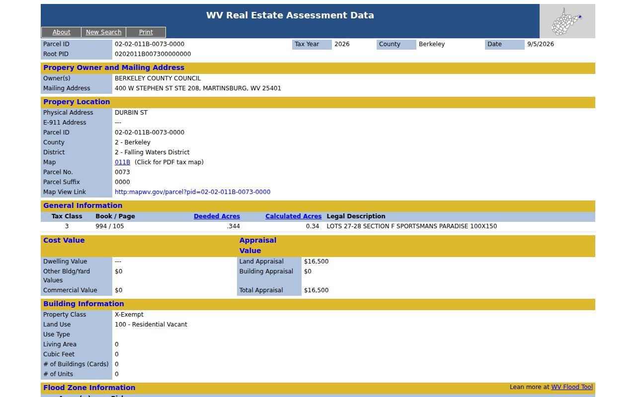
The image is a training example, not a private-resident finding. It shows that owner, location, legal land, tax value, and flood display are separate claims.
Keep the date. The sample is marked tax year 2026 and dated September 1, 2026; another parcel may reflect a different cycle.
Search Berkeley Streets by Parcel
The Berkeley County tax inquiry works best when the map has supplied district, map, parcel, and suffix. It also accepts taxpayer and account information. No ZIP field appeared, so this tool is not a ZIP directory or a full occupant roll.
| Search label | Input | Required? | Street use |
|---|---|---|---|
| Taxpayer name | Two text inputs | Not exposed | Check owner spelling |
| Account number | Two inputs | Not exposed | Open known account |
| Year, ticket, suffix | Three inputs | Not exposed | Narrow one bill |
| District, map, parcel | Selects and subparcel | Not exposed | Bridge map to tax |
| Year and status | Limit and selects | Not exposed | Separate real or personal and paid or unpaid |
The Assessor maintains tax maps and property records at 400 West Stephen Street, Suite 106, and can be reached at 304-264-1904. Online results can be checked there when a parcel is split, merged, exempt, vacant, or missing an E-911 label.
Berkeley Records Indexed by Address
No single Berkeley County street directory includes all residents. Several records can be compared, but the date and purpose control what each name means.
| Address source | Keeper | Evidence | Access |
|---|---|---|---|
| Assessment and tax | Assessor and Sheriff | Owner, taxpayer, mailing and situs, PID | Online, office, phone |
| Parcel map | County GIS and MapWV | Geometry, address, community, assessment link | Free viewers |
| Deeds and liens | County Clerk | Parties, legal land, book/page | Paid virtual, office, copies, archives |
| Voter file | County Clerk elections | Allowed residence, status, party, precinct | State lookup or statutory request |
| Permits | Planning and engineering | Permit, owner, subdivision, lot | Online and office |
| Directories and maps | Library and archives | Dated names, numbers, buildings, blocks | Reading rooms, catalogs, microfilm |
When the web stops, the chain continues by phone or in person at the Assessor and County Clerk, then through library and archival collections. A focused West Virginia Freedom of Information Act request may seek a reasonably specific, nonexempt county record. It does not unlock a confidential file or force the county to create a directory.
Official Berkeley Street Names
The road and street ordinance requires a Berkeley County Road Name Index. The IT Director authorizes names for roads serving three or more occupied buildings, resolves duplicate or confusing names, and requires subdivision streets to be approved before use. The index itself was not found as a public download.
This explains why a current E-911 name may differ from an old route, farm, tract, or subdivision description. If an address fails, try the former road form, highway number, community, subdivision, and nearest cross street. No official countywide renumbering crosswalk or dated street-name history was located.
Note: Keep the source spelling, then place a standardized address beside it so each form can be tested later.
Martinsburg Addressing Changed Hands
A 2025 intergovernmental addressing agreement assigned countywide public-safety, E-911, and GIS duties to the county. It also describes the County 9-1-1 Addressing Office taking responsibility for new addresses, verification, and address changes within Martinsburg.
Older Martinsburg records may reflect city practice, while a current check may go through the county. The transition does not prove that any given road was renamed. It identifies today's custodian and warns that old directions can be stale.
Follow Berkeley Streets Into Deeds
A deed chain carries a current parcel into recorded land instruments. Start with book/page and legal description. Find the buyer, called the grantee, and seller, called the grantor. Search the seller as an earlier buyer, then compare acreage, subdivision, lot, adjoining tracts, and prior references.
The clerk's current page states deeds from 1945 forward, while a 2025 virtual-courthouse agreement says 1970 forward. Keep that conflict visible. Deeds of trust are stated from 1918, liens and judgments from 1998, and releases from 1992. Virtual access requires registration and currently costs $15 per month, plus $1.50 for the first two pages and $1 for each later page. Older deeds continue through the clerk, West Virginia Archives, and FamilySearch reels, including a 1772 to 1926 catalog.
The County Clerk is at 400 West Stephen Street, Suite 103, Martinsburg, phone 304-264-1927 and fax 304-267-1794. Those channels matter when an image is missing or the online range ends.
Berkeley Permits Date Street Work
The Berkeley permit search accepts permit number, owner, subdivision, and lot. It can help when the street number changed or the parcel is better known by a plat label.
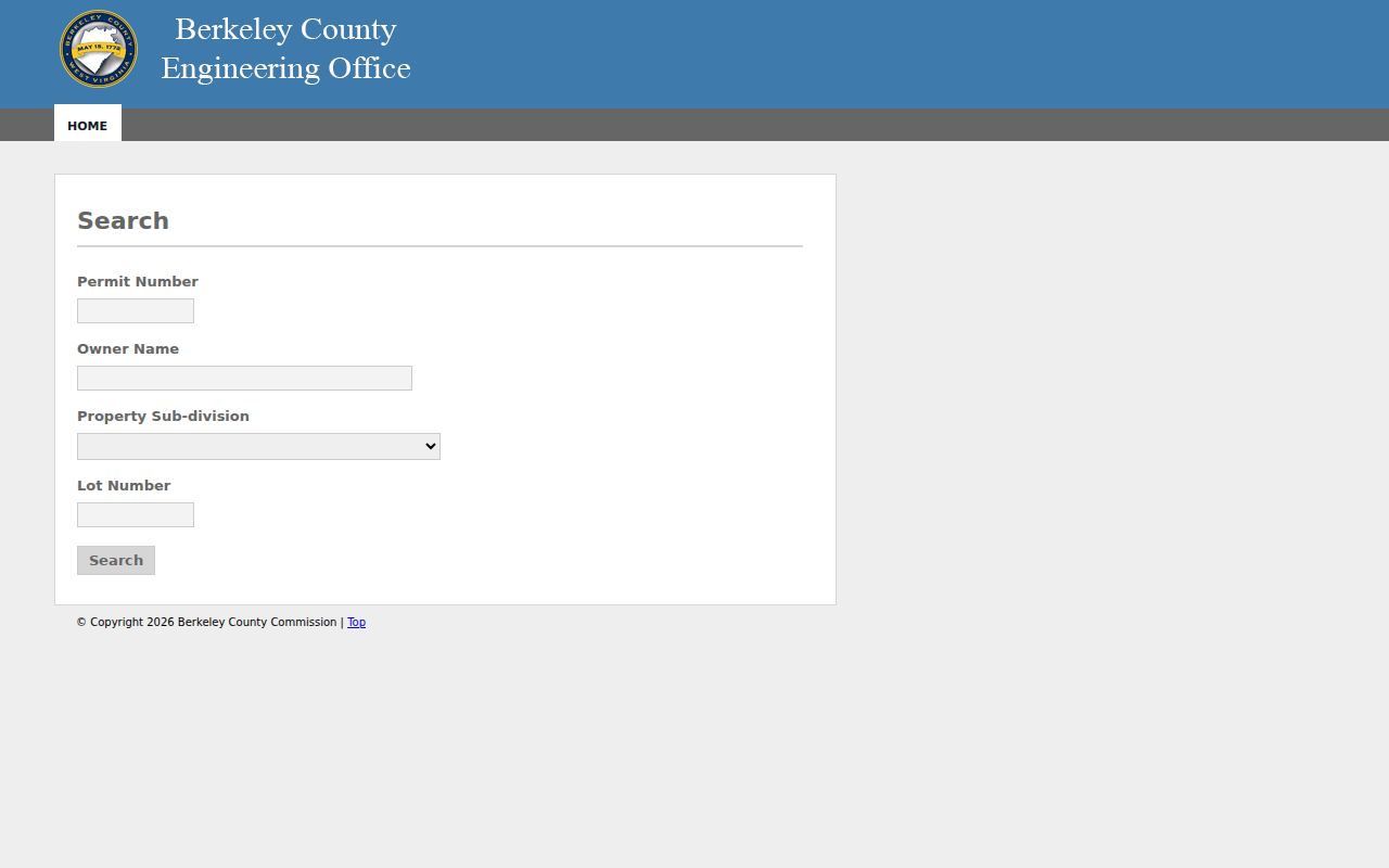
The captured form supports a dated construction lead, not a claim about every resident. One Stop also advertises advanced search, inspections, and open data, but stable fields and historical start dates were not confirmed. Ask for the underlying permit file when a result lacks dates.
Place Berkeley Streets in Precincts
The county polling lookup takes an address and returns district, precinct, House district, Senate district, and polling place. It adds current election geography, but boundaries and polling locations change.
The state voter form is different. It requires first name, last name, and date of birth, not street or ZIP. Public lists may include a residence address, party, status, and precinct, while phone, email, Social Security, and driver-license data are excluded. Inspection is available at the clerk terminal or in print. A noncommercial list request must follow statutory format, cost, and use limits.
Note: A polling result shows election geography for an address; it does not name all occupants or reveal ballot choices.
Read Old Berkeley Streets Carefully
Historical address research uses dated layers. Martinsburg directory holdings run unevenly from 1898 through 2016. A criss-cross section, when present, lets a researcher find a number first. The full collections belong on the Berkeley County city directory page; here they act only as an address bridge.
Sanborn maps add block context without naming occupants. WVU lists Martinsburg maps for 1885, 1891, 1897, 1902, 1907, and 1913. The Library of Congress preserves 15 sheets from August 1907. Compare a sheet's street layout and lot with a dated directory, deed, newspaper, or obituary.
For land before modern numbers, the Berkeley County House Tax of 1798 and courthouse survey files offer an early path. They may date a building or tract, but cannot be forced into a current number without maps and legal descriptions.
Limits of Berkeley Street Records
The assessor names the assessed owner and tax mailing party, not every occupant. Deeds identify instrument parties. Permits identify an applicant or owner for a project. A voter source omits unregistered people and may reflect an older status. Delivery, utility, school-child, and private association lists were not found as public county datasets.
Qualified participants in the West Virginia Address Confidentiality Program may use a substitute address with mail forwarding for four years. Other records can be sealed or redacted. An empty result may mean an old label, missing page, limited coverage, or lawful protection.
Lawful use only. Use Berkeley County address records for legitimate personal research. Never use a street directory to stalk, harass, intimidate, or harm another person.
A careful finding says current assessment owner, deed party, registered voter, dated directory entry, or map-only context. That is more accurate than calling every public name a resident.